

Portishead Hole is a tidal pool at one end of Portbury Wharf salt marsh by Portishead Pier and the marina lock gates. On the very highest tides the Hole is hidden beneath 40 feet or so of water but as the tide ebbs the surrounding mud banks are revealed in all their glory.
 In winter flocks of dunlin and redshank gather here but at other times of the year you can get anything from common sandpipers, oystercatchers and curlew to the occasional kingfisher.
All but 2 of these 9 sketches are at low or mid water so mud is much in evidence – far more interesting than a high tide view!

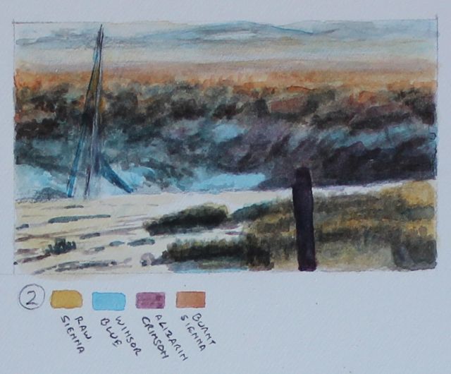
1. Looking across the Hole towards Portishead Pier and the Welsh hills just before low water . . . never boring and ever changing. Denny Island is just visible to the left.
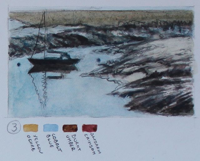
2. At low water the masts of a yacht nestling in the mud Hole are just visible. This is early in the morning looking towards the salt marsh with the rising sun glinting off the mud.
3. The salt marsh stretches off into the distance and a single yacht is silhouetted in the Hole as the sun rises over the marsh. This is low water on a neap tide, if it was a spring tide the water level would be much lower or even completely dried out.
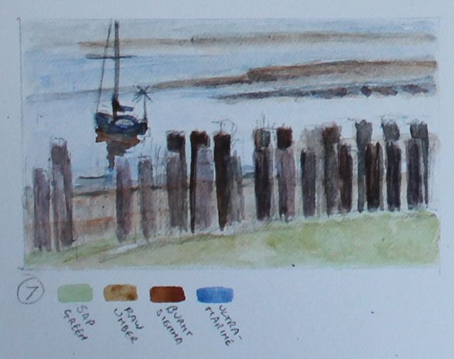
PS. Note on spring and neap tides
Spring tides (nothing to do with the season) are stronger with a greater tidal range than neap tides so the low water level is lower and the high water level is higher than on neaps. They alternate weekly with spring tides just after the full and new moon and neap tides just after the first and last quarter moon.
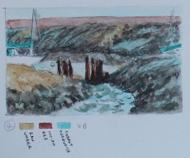
4. One of my favourite views into the Hole. Two yachts are just visible, one far left and the other far right. The estuary is on the other side of the back mud bank.
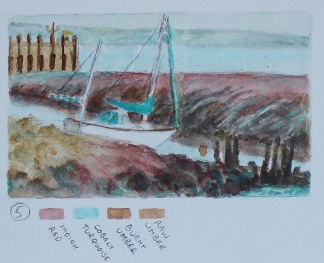
5. The early morning light has given the mud a glorious red hue. It is low water on a neap tide and a yacht is resting at an angle in the mud with Portishead Pier off to the left.

6. This is a good view of the Hole at around 2 hours after low water on a neap tide (the Hole dries out completely on a very low spring tide). When the tide turns the water floods in past the pier.
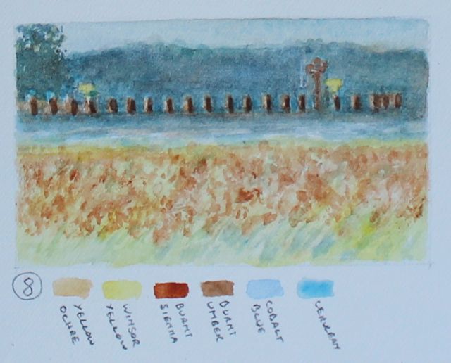
7. The remains of one of the old jetties with a yacht moored in the Hole. The edge of the salt marsh is just visible as are the distant quays of Royal Portbury Dock.
 8. This is a view looking from the salt marsh across the now flooded Hole towards the pier on a high spring tide. One of the most extraordinary and exciting things about the Severn Estuary is its amazing tidal range which can be as much as 49 feet (15 metres). On a really big spring tide the water level will rise even higher here.
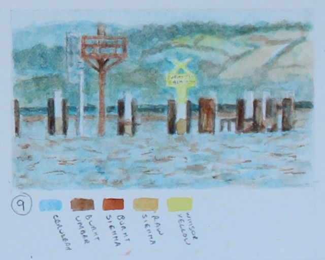 A closer view of the end of Portishead Pier on a high spring tide. As the pier is all but underwater on the very highest tides the yellow sign is there to warn boats of “submerged obstructions”.
What is the origin of the Hole?
Unfortunately I do not know its history but if anyone can enlighten me I would love to hear about it. I am not even sure whether the Hole was created naturally by the streams and rhines (drainage ditches) running into the estuary here or whether it was manmade.
I did find a reference in the London Gazette of 1862 which perhaps gives a clue. The Bristol and Portishead Pier and Railway Company applied to Parliament to build a second pier 30 chains (about 600 metres) from the existing pier and ….
“. . . to dredge, scour, and deepen the bed or soil of the River Severn, opposite to the entrance and along the western side of the said pier . . .”
Is this the origin? Here is a link to the relevant page in the1862 London Gazette.
Related post
Teal – down and dirty
You must be logged in to post a comment.